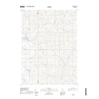
2018 Map of Argyle
USGS Topo · Published 2018About this map
The East Branch Pecatonica River winds through this section of the Driftless Area, where the village of Argyle serves as a primary hub near the confluence of Dougherty Cr and the river. Further south, the smaller settlement of Woodford sits alongside the same river system, illustrating the historical importance of these waterways for early site selection and transport in Lafayette County. The terrain is defined by distinct drainages like Puddledock Hollow and Jockey Hollow, which cut through the landscape and dictate the path of local roads such as Puddle Dock Rd and Jordan Wiota Rd. Genealogists will find several notable burial sites documented, including Calvary Cem and Woodlawn Cem on the northern outskirts of Argyle, as well as the more isolated Lewis Cem situated in the central portion of the quadrangle.
Find a feature on this map
59 named features on this map. Tap any name to fly to it.
Don’t see what you’re looking for? This feature index may not catch every label — zoom into the map to look around manually.
Map Details
Editions of this 2018 Argyle Map
This is the sole edition of this map. No revisions or reprints were ever made.
Other maps of this area

1920 · Monroe
USGS Topo · 1:62,500

1922 · Monroe
USGS Topo · 1:62,500

1923 · Blanchardville
USGS Topo · 1:62,500

1923 · New Glarus
USGS Topo · 1:62,500

1923 · South Wayne
USGS Topo · 1:62,500

1954 · Rockford
USGS Topo · 1:250,000

1955 · Rockford
USGS Topo · 1:250,000

1958 · Rockford
USGS Topo · 1:250,000
1962 · New Glarus
USGS Topo · 1:62,500
1962 · Monroe NW
USGS Topo · 1:24,000