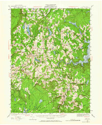
1928 Map of Ariel
USGS Topo · Published 1964About this map
Lake Wallenpaupack dominates the eastern landscape of this Wayne County survey, marking the scale of early 20th-century water management and recreation in the region. The map reveals a dense network of early crossroads and rural centers, from the industrial Wallenpaupack Mills to the recreational hub of Lake Ariel. To the west, the Moosic Mountains create a natural barrier, while the Erie R.R. and Western R.R. provide the necessary infrastructure for moving goods through the high country. Small rural institutions such as St Marys Ch, Frisbie Sch, and Zion Ch are scattered throughout the townships of Salem and Sterling, providing essential landmarks for genealogists tracking family history in these tight-knit communities. The presence of Haads Mill and numerous swamps like Tisdale Swamp further illustrate the era's reliance on local natural resources and the drainage patterns of the Pocono plateau.
Find a feature on this map
128 named features on this map. Tap any name to fly to it.
Don’t see what you’re looking for? This feature index may not catch every label — zoom into the map to look around manually.
Map Details
Editions of this 1928 Ariel Map
4 editions found

Other maps of this area

1889 · Scranton
USGS Topo · 1:62,500

1891 · Scranton
USGS Topo · 1:62,500

1892 · Honesdale
USGS Topo · 1:62,500

1892 · Dundaff
USGS Topo · 1:62,500

1893 · Scranton
USGS Topo · 1:62,500

1919 · Pocono
USGS Topo · 1:62,500

1920 · Damascus
USGS Topo · 1:62,500

1921 · Pocono
USGS Topo · 1:62,500

1922 · Stoddartsville
USGS Topo · 1:62,500

1923 · Damascus
USGS Topo · 1:62,500
Featured Places
- Cherry Ridge Township, PA
- South Canaan Township, PA
- Sterling Township, PA
- Clifton Township, PA
- Lake Township, PA