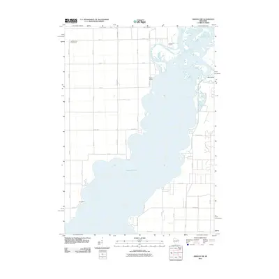
2010 Map of Arkdale NW
USGS Topo · Published 2010About this map
Petenwell Lake dominates this central Wisconsin landscape, where the Wisconsin River was harnessed to create one of the state's largest reservoirs. Along the eastern shoreline, the settlement of New Rome sits near the confluence of Fourteenmile Creek, reflecting the area's development into a recreational and residential hub by the early 21st century. The map reveals a transition from the structured grid of rural roads like County Line Rd and 20th Ave N to the more organic residential street patterns bordering the water, such as Archer Ave and Feather Trl. To the north, Greenwood Cemetery and the Cranberry Rock Lookout Tower provide fixed historical points of reference amidst a landscape shaped by hydraulic engineering. Landforms like Yellow Banks and Halls Point offer clues to the original river channel's topography before the basin was flooded.
Find a feature on this map
37 named features on this map. Tap any name to fly to it.
Don’t see what you’re looking for? This feature index may not catch every label — zoom into the map to look around manually.
Map Details
Editions of this 2010 Arkdale NW Map
This is the sole edition of this map. No revisions or reprints were ever made.
Other maps of this area

1953 · Eau Claire
USGS Topo · 1:250,000

1955 · Green Bay
USGS Topo · 1:250,000

1957 · Wisconsin Rapids
USGS Topo · 1:48,000

1957 · Pittsville
USGS Topo · 1:48,000

1958 · Eau Claire
USGS Topo · 1:250,000

1958 · Arkdale
USGS Topo · 1:48,000

1958 · Necedah
USGS Topo · 1:48,000

1964 · Eau Claire
USGS Topo · 1:250,000

1967 · Roche A Cri
USGS Topo · 1:24,000

1967 · Arkdale NE
USGS Topo · 1:24,000