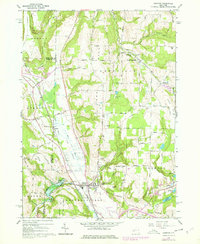
1965 Map of Arkport
USGS Topo · Published 1978About this map
The Canisteo River valley dominates this mid-1960s landscape, anchored by the village of Arkport and the major flood control works at Arkport Dam. This terrain reflects the complex glacial legacy of the region, featuring the dramatic Sugar Creek Glen and high elevations like Dansville Hill and Oak Hill. The map documents a rural network of farm-to-market roads such as Stage Road and Kurtz Hollow Road, which connect small hamlets like South Dansville and Dotys Corners.
Find a feature on this map
62 named features on this map. Tap any name to fly to it.
Don’t see what you’re looking for? This feature index may not catch every label — zoom into the map to look around manually.
Map Details
Editions of this 1965 Arkport Map
3 editions found
Other maps of this area

1902 · Wayland
USGS Topo · 1:62,500

1904 · Wayland
USGS Topo · 1:62,500

1905 · Nunda
USGS Topo · 1:62,500

1915 · Hornell
USGS Topo · 1:62,500

1916 · Canaseraga
USGS Topo · 1:62,500

1918 · Hornell
USGS Topo · 1:62,500

1940 · Canaseraga
USGS Topo · 1:62,500

1942 · Wayland
USGS Topo · 1:31,680

1942 · Dansville
USGS Topo · 1:31,680

1943 · Ossian
USGS Topo · 1:24,000