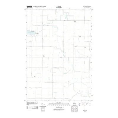
2010 Map of Arland
USGS Topo · Published 2010About this map
Turtle Creek winds through a landscape of structured rural blocks and scattered homesteads, anchoring the agricultural character of this Barron County township. The township center at Arland and the nearby Twin Town serve as small nodes within a strictly gridded road network, where numbered avenues like 10th Ave and streets such as 5th ST define property boundaries. For genealogists, the map is particularly detailed in its placement of local burial grounds, including Bethany Cemetery, Mount Hope Cemetery, and the Independent Cemetery. Water management is evident along the western edge at the Big Moon Lake 2WP1478 Dam, which regulates Big Moon Lake. These features, along with several smaller waterways like Silver Creek and Jones Creek, illustrate a community shaped by its reliance on the land and the drainage of the surrounding prairie and woodland.
Find a feature on this map
42 named features on this map. Tap any name to fly to it.
Don’t see what you’re looking for? This feature index may not catch every label — zoom into the map to look around manually.
Map Details
Editions of this 2010 Arland Map
This is the sole edition of this map. No revisions or reprints were ever made.
Other maps of this area

1948 · Downing
USGS Topo · 1:62,500

1949 · Ridgeland
USGS Topo · 1:62,500

1950 · Downing
USGS Topo · 1:62,500

1950 · Turtle Lake
USGS Topo · 1:62,500

1951 · Ridgeland
USGS Topo · 1:62,500

1951 · Barron
USGS Topo · 1:62,500

1952 · Turtle Lake
USGS Topo · 1:62,500

1953 · Rice Lake
USGS Topo · 1:250,000

1953 · Stillwater
USGS Topo · 1:250,000

1955 · Stillwater
USGS Topo · 1:250,000