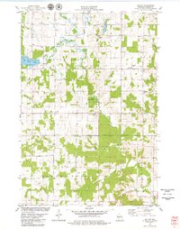
1978 Map of Arland
USGS Topo · Published 1979About this map
Arland and the surrounding rural townships of Turtle Lake, Vance Creek, and Prairie Farm characterize this Barron County landscape in the late 1970s. The map illustrates a deeply rooted agricultural and religious community, marked by a high density of country churches and cemeteries, such as Bethany Ch and St Johns Cem. Numerous small watercourses, including Turtle Creek, Moon Creek, and Silver Creek, carve through the glacial terrain, which is dotted with active Gravel Pits and a Quarry near the southern boundary. These features, along with the State Wildlife Area, suggest a balance between resource extraction and land conservation. Researchers will find precise detail of the rural road network connecting isolated farmsteads and small crossroads like Twin Town, reflecting the enduring settlement patterns of western Wisconsin.
Find a feature on this map
33 named features on this map. Tap any name to fly to it.
Don’t see what you’re looking for? This feature index may not catch every label — zoom into the map to look around manually.
Map Details
Editions of this 1978 Arland Map
This is the sole edition of this map. No revisions or reprints were ever made.
Other maps of this area

1948 · Downing
USGS Topo · 1:62,500

1949 · Ridgeland
USGS Topo · 1:62,500

1950 · Downing
USGS Topo · 1:62,500

1950 · Turtle Lake
USGS Topo · 1:62,500

1951 · Ridgeland
USGS Topo · 1:62,500

1951 · Barron
USGS Topo · 1:62,500

1952 · Turtle Lake
USGS Topo · 1:62,500

1953 · Rice Lake
USGS Topo · 1:250,000

1953 · Stillwater
USGS Topo · 1:250,000

1955 · Stillwater
USGS Topo · 1:250,000