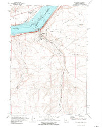
1971 Map of Arlington
USGS Topo · Published 1972About this map
The Columbia River and Lake Umatilla define this mid-century view of the Oregon-Washington border, where the town of Arlington serves as a critical junction for the Union Pacific railroad and regional transport. The map illustrates a landscape transition, from the industrial activity at Arlington Municipal Airport and various quarries to the agricultural reaches of Hurlburt Flats.
Find a feature on this map
29 named features on this map. Tap any name to fly to it.
Don’t see what you’re looking for? This feature index may not catch every label — zoom into the map to look around manually.
Map Details
Editions of this 1971 Arlington Map
2 editions found
Other maps of this area

1916 · Arlington
USGS Topo · 1:125,000

1953 · The Dalles
USGS Topo · 1:250,000

1956 · The Dalles
USGS Topo · 1:250,000

1957 · The Dalles
USGS Topo · 1:250,000

1962 · Heppner Junction
USGS Topo · 1:24,000

1962 · Wood Gulch
USGS Topo · 1:24,000

1964 · Turner Butte
USGS Topo · 1:24,000

1964 · Shutler Flat
USGS Topo · 1:24,000

1964 · Hickland Butte
USGS Topo · 1:24,000
1964 · Horn Butte
USGS Topo · 1:24,000