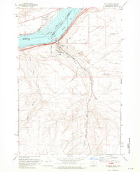
1971 Map of Arlington
USGS Topo · Published 1971About this map
Arlington sits at the confluence of the Columbia River and the winding course of China Creek in the early 1970s. This period captures the town as it interfaces with Lake Umatilla, a major reservoir formed behind the John Day Dam. The map highlights the town's infrastructure, including the High Sch, a Cem, and the Arlington Municipal Airport on the plateau to the east.
Find a feature on this map
32 named features on this map. Tap any name to fly to it.
Don’t see what you’re looking for? This feature index may not catch every label — zoom into the map to look around manually.
Map Details
Editions of this 1971 Arlington Map
2 editions found
Other maps of this area

1916 · Arlington
USGS Topo · 1:125,000

1953 · The Dalles
USGS Topo · 1:250,000

1956 · The Dalles
USGS Topo · 1:250,000

1957 · The Dalles
USGS Topo · 1:250,000

1962 · Heppner Junction
USGS Topo · 1:24,000

1962 · Wood Gulch
USGS Topo · 1:24,000

1964 · Turner Butte
USGS Topo · 1:24,000

1964 · Shutler Flat
USGS Topo · 1:24,000

1964 · Hickland Butte
USGS Topo · 1:24,000
1964 · Horn Butte
USGS Topo · 1:24,000