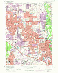
1962 Map of Arlington Heights
USGS Topo · Published 1973About this map
The Des Plaines River corridor and its surrounding preserves anchor this study of the suburban landscape in Northwest Cook County. The map documents a period of rapid post-war expansion where once-separate farming communities like Arlington Heights and Mt Prospect begin to merge into a continuous urban corridor. This growth is evidenced by the purple-tinted urban extensions and the proliferation of infrastructure, from the Randhurst Shopping Center to the massive Chicago O'Hare International Airport footprint at the southern edge. Large institutional properties and cemeteries, including the sprawling All Saints Cemetery and Memory Gardens Cemetery, provide significant open space alongside the Ned Brown Preserve. Transportation networks define the era's development, as the Northwest Tollway and the Chicago and North Western railway lines facilitate the movement between these growing residential hubs and the city beyond.
Find a feature on this map
124 named features on this map. Tap any name to fly to it.
Don’t see what you’re looking for? This feature index may not catch every label — zoom into the map to look around manually.
Map Details
Editions of this 1962 Arlington Heights Map
This is the sole edition of this map. No revisions or reprints were ever made.
Other maps of this area

1891 · Riverside
USGS Topo · 1:62,500

1893 · Riverside
USGS Topo · 1:62,500

1900 · Riverside
USGS Topo · 1:62,500

1900 · Highwood
USGS Topo · 1:62,500

1901 · Riverside
USGS Topo · 1:62,500

1908 · Wheaton
USGS Topo · 1:62,500

1923 · Barrington
USGS Topo · 1:62,500

1927 · Arlington Heights
USGS Topo · 1:24,000

1928 · Elmhurst
USGS Topo · 1:24,000

1928 · Wheeling
USGS Topo · 1:24,000