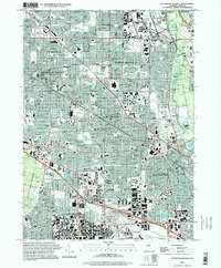
1995 Map of Arlington Heights
USGS Topo · Published 1999About this map
Arlington Heights and Mt Prospect define this dense suburban landscape in the mid-1990s, where residential growth is woven around an established industrial and institutional infrastructure. The Chicago and North Western corridor serves as the spine for these communities, linking them to nearby Chicago. The map reveals a high concentration of religious and educational landmarks, such as St Viator High Sch and the Carmelite Monastery, alongside significant green spaces like Busse Forest North.
Find a feature on this map
139 named features on this map. Tap any name to fly to it.
Don’t see what you’re looking for? This feature index may not catch every label — zoom into the map to look around manually.
Map Details
Editions of this 1995 Arlington Heights Map
This is the sole edition of this map. No revisions or reprints were ever made.
Other maps of this area

1891 · Riverside
USGS Topo · 1:62,500

1893 · Riverside
USGS Topo · 1:62,500

1900 · Riverside
USGS Topo · 1:62,500

1900 · Highwood
USGS Topo · 1:62,500

1901 · Riverside
USGS Topo · 1:62,500

1908 · Wheaton
USGS Topo · 1:62,500

1923 · Barrington
USGS Topo · 1:62,500

1927 · Arlington Heights
USGS Topo · 1:24,000

1928 · Elmhurst
USGS Topo · 1:24,000

1928 · Wheeling
USGS Topo · 1:24,000