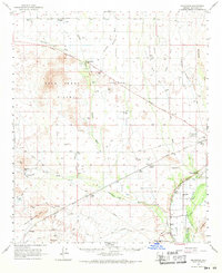
1962 Map of Arlington
USGS Topo · Published 1971About this map
The agricultural and desert landscapes of western Maricopa County are defined here by a network of washes and irrigation canals along the Gila River. This early 1960s survey illustrates a region in transition, where established settlements like Arlington and Tonopah supported local farming and ranching operations. The presence of the Arlington Canal and the Hassayampa Cotton Gin points to the importance of water management and cotton production in the local economy during this era.
Find a feature on this map
44 named features on this map. Tap any name to fly to it.
Don’t see what you’re looking for? This feature index may not catch every label — zoom into the map to look around manually.
Map Details
Editions of this 1962 Arlington Map
2 editions found

Other maps of this area

1942 · Vicksburg
USGS Topo · 1:250,000

1951 · Dendora Valley
USGS Topo · 1:62,500

1951 · Cotton Center
USGS Topo · 1:62,500

1951 · Woolsey Peak
USGS Topo · 1:62,500

1954 · Phoenix
USGS Topo · 1:250,000

1957 · Phoenix
USGS Topo · 1:250,000

1957 · White Tank Mts.
USGS Topo · 1:62,500

1958 · Phoenix
USGS Topo · 1:250,000

1958 · Buckeye NW
USGS Topo · 1:24,000

1958 · Hassayampa
USGS Topo · 1:24,000