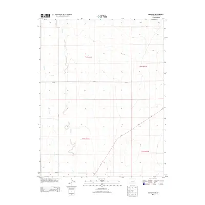
2013 Map of Arlington NE
USGS Topo · Published 2013About this map
Adobe Creek meanders through this portion of Kiowa County, carving a winding path through the High Plains landscape of southeastern Colorado. The drainage pattern of Adobe Creek and its tributary, Johns Creek, defines the local topography, which is otherwise organized by the rigid grid of the Public Land Survey System. This 2013 survey illustrates a rural environment primarily shaped by agricultural transport and water management. Modern infrastructure is represented by Co-96, which cuts diagonally across the southern half of the map, providing a primary arterial connection through the region. Secondary travel is facilitated by a network of gravel and dirt routes such as CO Road P and CO Road 9. The map provides a clear look at the township and range boundaries that have governed land ownership and development in this section of the state since the initial homesteading era.
Find a feature on this map
11 named features on this map. Tap any name to fly to it.
Don’t see what you’re looking for? This feature index may not catch every label — zoom into the map to look around manually.
Map Details
Editions of this 2013 Arlington NE Map
This is the sole edition of this map. No revisions or reprints were ever made.
Other maps of this area

1891 · Arroyo
USGS Topo · 1:125,000

1891 · Las Animas
USGS Topo · 1:125,000

1893 · Arroyo
USGS Topo · 1:125,000

1893 · Las Animas
USGS Topo · 1:125,000

1954 · Lamar
USGS Topo · 1:250,000

1958 · Lamar
USGS Topo · 1:250,000

1974 · Haswell
USGS Topo · 1:24,000

1974 · Arlington NE
USGS Topo · 1:24,000
1978 · Long Lake
USGS Topo · 1:24,000
1978 · Arlington
USGS Topo · 1:24,000