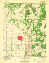
1959 Map of Arma
USGS Topo · Published 1960About this map
The Crawford County coalfields dominate this 1959 landscape, where extensive Strip Mines and tailings piles surround the population centers of Arma and Franklin. The industrial character of the era is evident in the dense network of railways, including the Missouri Pacific and Kansas City Southern, which once serviced the numerous pits and quarries. Scattered between these excavations are small, worker-associated settlements like Coalvale, Croweburg, and Foxtown, alongside local landmarks such as the Sheffield Sch and Foxtown Union Sch. Beyond the heavy industry, the terrain is marked by prominent elevations like Bunker Hill and Breezy Hill, while rural life is anchored by sites like Englevale Cem and the Garden of Memories Cem. The map provides a clear look at the proximity of extraction operations to established towns and rural farmsteads.
Find a feature on this map
39 named features on this map. Tap any name to fly to it.
Don’t see what you’re looking for? This feature index may not catch every label — zoom into the map to look around manually.
Map Details
Editions of this 1959 Arma Map
2 editions found
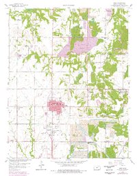
Other maps of this area

1884 · Fort Scott
USGS Topo · 1:125,000

1886 · Joplin
USGS Topo · 1:125,000

1886 · Fort Scott
USGS Topo · 1:125,000

1893 · Fort Scott
USGS Topo · 1:125,000

1894 · Joplin
USGS Topo · 1:125,000

1943 · Cherokee
USGS Topo · 1:62,500

1945 · Pittsburg
USGS Topo · 1:62,500

1945 · Cherokee
USGS Topo · 1:62,500

1947 · Joplin
USGS Topo · 1:250,000

1947 · Pittsburg
USGS Topo · 1:62,500