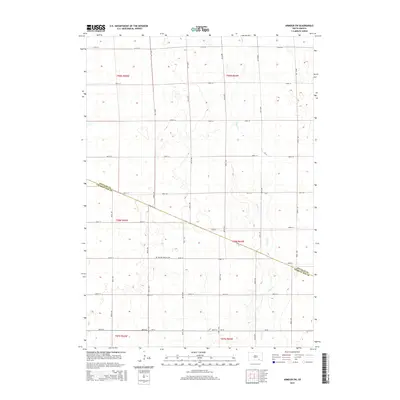
2015 Map of Armour SW
USGS Topo · Published 2015About this map
High plains agriculture and a strictly organized section-line grid define this landscape along the border of Douglas and Charles Mix counties. The primary landmark of historical interest is the German Reform Cem, located along 283rd St, which serves as a quiet marker of the region's ethnic settlement patterns. The terrain is relatively flat, drained primarily by the winding course of Andes Cr, which cuts across the township boundaries of t99n r64w and t98n r64w. The area is interlaced with local routes like 387th Ave and 389th Ave, illustrating a region dominated by large-scale farming and sparse rural homesteads characteristic of the South Dakota prairie.
Find a feature on this map
26 named features on this map. Tap any name to fly to it.
Don’t see what you’re looking for? This feature index may not catch every label — zoom into the map to look around manually.
Map Details
Editions of this 2015 Armour SW Map
This is the sole edition of this map. No revisions or reprints were ever made.
Other maps of this area

1955 · Mitchell
USGS Topo · 1:250,000

1959 · Mitchell
USGS Topo · 1:250,000

1964 · Wagner NE
USGS Topo · 1:24,000

1964 · Ravinia
USGS Topo · 1:24,000

1964 · Lake Andes
USGS Topo · 1:24,000
1977 · Wagner NE
USGS Topo · 1:24,000
1977 · Lake Andes
USGS Topo · 1:24,000

1979 · Geddes SE
USGS Topo · 1:24,000

1979 · New Holland
USGS Topo · 1:24,000
1979 · Armour
USGS Topo · 1:24,000
Featured Places
- Chester Township, SD
- Grandview Township, SD
- Goose Lake Township, SD
- Iowa Township, SD
- Howard Township, SD