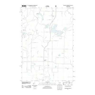
2011 Map of Armstrong Creek
USGS Topo · Published 2011About this map
Armstrong Creek and the small settlement of Fence anchor this 2011 survey of northeastern Wisconsin. The landscape is defined by a dense network of glacial water bodies and drainage systems, including Lake Laura, Forest Lake, and the distinctly named Nadjak Lake. Human impact on the hydrology is visible at the Mud Creek D7777 Dam near the northern boundary, while the legacy of the region's logging era is preserved in the path of Goodman Grade Rd. Local genealogy and community history are anchored by Hillside Cemetery in the north and Pine Hill Cemetery further south. The map details a transition from organized township grids to more winding recreational routes like Fern Acres Dr and Oneonta Dr, illustrating the area's dual character as both a rural residence and a destination for lakefront camps like Camp B Lake.
Find a feature on this map
73 named features on this map. Tap any name to fly to it.
Don’t see what you’re looking for? This feature index may not catch every label — zoom into the map to look around manually.
Map Details
Editions of this 2011 Armstrong Creek Map
This is the sole edition of this map. No revisions or reprints were ever made.
Other maps of this area

1939 · Goodman
USGS Topo · 1:48,000

1939 · Laona
USGS Topo · 1:48,000

1939 · Long Lake
USGS Topo · 1:48,000

1941 · Florence
USGS Topo · 1:48,000

1946 · Laona
USGS Topo · 1:48,000

1946 · Goodman
USGS Topo · 1:48,000

1948 · Long Lake
USGS Topo · 1:48,000

1954 · Iron Mountain
USGS Topo · 1:250,000

1959 · Iron Mountain
USGS Topo · 1:250,000
1962 · Florence SW
USGS Topo · 1:24,000