
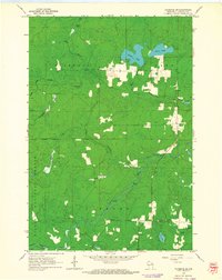
2015 Map of Armstrong Creek
USGS Topo · Published 2015About this map
Armstrong Creek serves as the primary settlement hub within this section of the Nicolet National Forest, where the landscape is defined by an intricate network of glacial lakes and northern woodlands. This 2015 survey reveals a pattern of rural development concentrated along corridors like Co Hwy H and around water bodies such as Hilbert Lake and LaFaye Lake. Local heritage is preserved at sites like Hillside Cem and Pine Hill Cem, while the naming of Old Smith School Ln points to the area's educational history. The presence of the Goodman Grade Rd suggests a legacy of timber extraction or early rail transit, connecting the scattered residences to the larger forest infrastructure. Smaller water features like Petryk Lake, Nedjak Lake, and Camp B Lake dot the eastern half of the quadrangle, illustrating the dense hydrology characteristic of this portion of Marinette and Forest Counties.
Find a feature on this map
87 named features on this map. Tap any name to fly to it.
Don’t see what you’re looking for? This feature index may not catch every label — zoom into the map to look around manually.
Map Details
Editions of this 2015 Armstrong Creek Map
This is the sole edition of this map. No revisions or reprints were ever made.
Other maps of this area

1939 · Goodman
USGS Topo · 1:48,000

1939 · Laona
USGS Topo · 1:48,000

1939 · Long Lake
USGS Topo · 1:48,000

1941 · Florence
USGS Topo · 1:48,000

1946 · Laona
USGS Topo · 1:48,000

1946 · Goodman
USGS Topo · 1:48,000

1948 · Long Lake
USGS Topo · 1:48,000

1954 · Iron Mountain
USGS Topo · 1:250,000

1959 · Iron Mountain
USGS Topo · 1:250,000
1962 · Florence SW
USGS Topo · 1:24,000