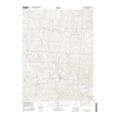
2016 Map of Armstrongs Mills
USGS Topo · Published 2016About this map
Armstrongs Mills and the surrounding townships of Belmont County sit at the heart of a highly dissected plateau, where the winding course of Captina Creek and its many tributaries have carved deep valleys into the landscape. This 2016 survey highlights a region defined by scattered agricultural settlements and the industrial footprint of the Nacco Slurry Refuse Impoundment, signaling the enduring role of the mining industry in the area. The map is particularly valuable for genealogists, as it preserves the locations of numerous family and community burial grounds, including the Scatterday and Perkins cemeteries, which are tucked away on high ridges far from the primary roads. From the village of Centerville in the north to Alledonia and Pugh Ridge in the south, the map illustrates how local geography and historical land patents, such as those in t5n r4w, continue to dictate the placement of roads like Armstrong Centerville Road.
Find a feature on this map
87 named features on this map. Tap any name to fly to it.
Don’t see what you’re looking for? This feature index may not catch every label — zoom into the map to look around manually.
Map Details
Editions of this 2016 Armstrongs Mills Map
This is the sole edition of this map. No revisions or reprints were ever made.
Other maps of this area

1903 · Flushing
USGS Topo · 1:62,500

1905 · Clarington
USGS Topo · 1:62,500

1905 · St. Clairsville
USGS Topo · 1:62,500

1905 · Woodsfield
USGS Topo · 1:62,500

1905 · Flushing
USGS Topo · 1:62,500

1935 · Clarington
USGS Topo · 1:62,500

1940 · Clarington
USGS Topo · 1:62,500

1949 · Clarksburg
USGS Topo · 1:250,000

1951 · Canton
USGS Topo · 1:250,000

1953 · Canton
USGS Topo · 1:250,000