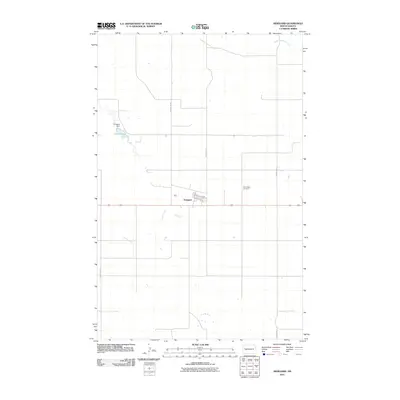
2011 Map of Arnegard
USGS Topo · Published 2011About this map
The town of Arnegard serves as a focal point for this McKenzie County landscape, where the intersection of Main St and the section-line road network defines the local community. This 2011 survey illustrates a transition from the structured residential grid of the town site to the expansive drainage systems of the surrounding plains. To the west, the Arnegard Dam regulates the waters of Lake Pechek, while the meandering paths of Tobacco Garden Creek and Timber Creek cut through the terrain, indicating the vital role of water management in this agricultural region. Genealogists and local historians can find significant landmarks such as the Wilmington Cemetery, situated east of the main settlement. The map also delineates the extensive rural transportation network, including County Rd 29 and County Rd 31, which connect the scattered homesteads and fields that characterize the northern plains.
Find a feature on this map
13 named features on this map. Tap any name to fly to it.
Don’t see what you’re looking for? This feature index may not catch every label — zoom into the map to look around manually.
Map Details
Editions of this 2011 Arnegard Map
This is the sole edition of this map. No revisions or reprints were ever made.
Other maps of this area

1953 · Watford City
USGS Topo · 1:250,000

1957 · Watford City
USGS Topo · 1:250,000

1958 · Stocke Butte
USGS Topo · 1:24,000

1958 · Tepee Buttes
USGS Topo · 1:24,000

1967 · Watford City
USGS Topo · 1:250,000

1972 · Bear Butte
USGS Topo · 1:24,000

1972 · Rawson
USGS Topo · 1:24,000

1978 · Watford City NW
USGS Topo · 1:24,000

1978 · Arnegard
USGS Topo · 1:24,000
1978 · Camp Creek East
USGS Topo · 1:24,000