
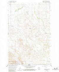
1958 Map of Tepee Buttes
USGS Topo · Published 1960About this map
The northern reaches of Theodore Roosevelt National Memorial Park anchor the southern boundary of this McKenzie County landscape in the late 1950s. The topography is defined by significant elevations, including Tepee Buttes, Clay Butte, and the interestingly named Stony Johnny Butte. These heights overlook a drainage network carved by Cherry Creek, Spring Creek, and Squaw Creek. Settlement in this era remains sparse, centered on small social and educational hubs such as Cherry Sch and Pleasant Hill Sch. This survey, conducted as part of the Missouri River Basin development program, captures the rural infrastructure of the North Dakota badlands before significant modern expansion. Local history is preserved in the presence of the Tepee Buttes Cem and Salem Cem, which serve as quiet markers of the families who established homesteads in this isolated terrain.
Find a feature on this map
15 named features on this map. Tap any name to fly to it.
Don’t see what you’re looking for? This feature index may not catch every label — zoom into the map to look around manually.
Map Details
Editions of this 1958 Tepee Buttes Map
2 editions found
Other maps of this area

1953 · Watford City
USGS Topo · 1:250,000

1957 · Watford City
USGS Topo · 1:250,000

1958 · Long X Divide
USGS Topo · 1:24,000

1958 · Sperati Point
USGS Topo · 1:24,000

1958 · Lone Butte
USGS Topo · 1:24,000

1958 · Stocke Butte
USGS Topo · 1:24,000

1959 · Lone Butte NW
USGS Topo · 1:24,000

1967 · Watford City
USGS Topo · 1:250,000

1978 · Arnegard
USGS Topo · 1:24,000

1978 · Schafer
USGS Topo · 1:24,000