
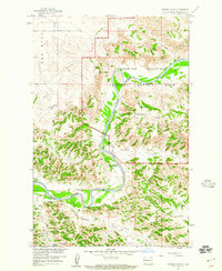
1958 Map of Sperati Point
USGS Topo · Published 1960About this map
The Little Missouri River meanders through this portion of McKenzie County, carving a distinct path through the badlands of western North Dakota. This 1958 field-checked survey highlights the early boundaries and terrain of the Theodore Roosevelt National Memorial Park, showcasing the dramatic elevation changes at Sperati Point and the Achenback Hills. The landscape is defined by its drainage systems, including Appel Creek, Corral Creek, and the deep incisions of Collar Draw.
Find a feature on this map
14 named features on this map. Tap any name to fly to it.
Don’t see what you’re looking for? This feature index may not catch every label — zoom into the map to look around manually.
Map Details
Editions of this 1958 Sperati Point Map
2 editions found
Other maps of this area

1953 · Watford City
USGS Topo · 1:250,000

1957 · Watford City
USGS Topo · 1:250,000

1958 · Long X Divide
USGS Topo · 1:24,000

1958 · Stocke Butte
USGS Topo · 1:24,000

1958 · Tepee Buttes
USGS Topo · 1:24,000

1967 · Watford City
USGS Topo · 1:250,000

1972 · Bear Butte
USGS Topo · 1:24,000

1974 · Wolf Coulee
USGS Topo · 1:24,000

1974 · Buckskin Butte
USGS Topo · 1:24,000
1974 · Ice Box Canyon
USGS Topo · 1:24,000