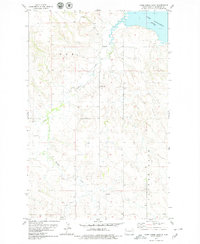
1978 Map of Camp Creek East
USGS Topo · Published 1979About this map
Lake Sakakawea defines the northern reaches of this McKenzie County landscape, its shoreline captured here during the late 1970s. The terrain is deeply etched by a network of drainages, primarily Timber Creek and Camp Creek, which channel through the varying elevations of the Missouri Plateau. Evidence of local industrial activity is present through the identification of a Scoria Pit and a Gravel Pit, reflecting the extraction of natural materials common in this region of North Dakota. The map also delineates historical land divisions, notably referencing P O E and P A T E N T G A T E, providing a clear view of the cadastral framework and resource management in the area during this period of the twentieth century.
Find a feature on this map
8 named features on this map. Tap any name to fly to it.
Don’t see what you’re looking for? This feature index may not catch every label — zoom into the map to look around manually.
Map Details
Editions of this 1978 Camp Creek East Map
This is the sole edition of this map. No revisions or reprints were ever made.
Other maps of this area

1911 · Ray
USGS Topo · 1:125,000

1953 · Williston
USGS Topo · 1:250,000

1953 · Watford City
USGS Topo · 1:250,000

1957 · Williston
USGS Topo · 1:250,000

1957 · Watford City
USGS Topo · 1:250,000

1967 · Watford City
USGS Topo · 1:250,000

1972 · Alexander
USGS Topo · 1:24,000

1972 · Rawson
USGS Topo · 1:24,000

1978 · Lake Jessie
USGS Topo · 1:24,000

1978 · Watford City NW
USGS Topo · 1:24,000