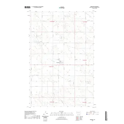
2020 Map of Arnegard
USGS Topo · Published 2020About this map
Arnegard serves as the central hub for this portion of McKenzie County, situated along a network of section-line roads and drainage patterns that define the western North Dakota plains. The settlement is positioned near the headwaters of Timber Cr, which winds through the landscape south of Arnegard Dam. This 2020 survey illustrates a rural environment shaped by the Rectangular Survey System, with the landscape divided into townships such as t150n r100w. Local history is anchored by the presence of Farland Cem in the northeast and Wilmington Cem to the east of town, providing clear points of reference for genealogists. The map also records specific local identifiers like Ball Diamond Rd and several numbered thoroughfares, including 26th ST NW, which delineate the prairie into its modern agricultural and residential grid.
Find a feature on this map
23 named features on this map. Tap any name to fly to it.
Don’t see what you’re looking for? This feature index may not catch every label — zoom into the map to look around manually.
Map Details
Editions of this 2020 Arnegard Map
This is the sole edition of this map. No revisions or reprints were ever made.
Other maps of this area

1953 · Watford City
USGS Topo · 1:250,000

1957 · Watford City
USGS Topo · 1:250,000
1958 · Stocke Butte
USGS Topo · 1:24,000
1958 · Tepee Buttes
USGS Topo · 1:24,000

1967 · Watford City
USGS Topo · 1:250,000
1972 · Bear Butte
USGS Topo · 1:24,000
1972 · Rawson
USGS Topo · 1:24,000
1978 · Watford City NW
USGS Topo · 1:24,000
1978 · Arnegard
USGS Topo · 1:24,000
1978 · Camp Creek East
USGS Topo · 1:24,000