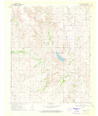
1970 Map of Arnett SW
USGS Topo · Published 1972About this map
Lake Lloyd Vincent and its surrounding Picnic Areas serve as a central geographic anchor in this 1970 survey of the Oklahoma-Texas borderlands. Located within the Ellis County State Wildlife Management Area, this reservoir is fed by Coon Creek and Commission Creek, illustrating the water management strategies of the era in the high plains. The terrain is defined by the drainage basins of Little Robe Creek and Hog Creek, where the landscape transitions from the upland plateaus of Hopewell to the rugged draws of Little Robe.
Find a feature on this map
19 named features on this map. Tap any name to fly to it.
Don’t see what you’re looking for? This feature index may not catch every label — zoom into the map to look around manually.
Map Details
Editions of this 1970 Arnett SW Map
This is the sole edition of this map. No revisions or reprints were ever made.
Other maps of this area

1954 · Perryton
USGS Topo · 1:250,000

1954 · Amarillo
USGS Topo · 1:250,000

1955 · Clinton
USGS Topo · 1:250,000

1955 · Woodward
USGS Topo · 1:250,000

1957 · Clinton
USGS Topo · 1:250,000

1958 · Perryton
USGS Topo · 1:250,000

1958 · Woodward
USGS Topo · 1:250,000

1958 · Amarillo
USGS Topo · 1:250,000

1966 · Antelope Hills NE
USGS Topo · 1:24,000

1966 · Antelope Hills
USGS Topo · 1:24,000