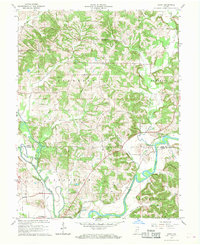
1966 Map of Arney
USGS Topo · Published 1968About this map
The Eel River and White River converge in the southern reaches of this mid-century landscape, defining a region where water and rail dictate the geography. The presence of the Penn Central railroad corridors underscores the area's role in the mid-1960s transportation network, connecting settlements like Worthington and Arney. While the rivers meander through the bottomlands, the topography rises toward Need Hill and Kelley Ridge, providing a diverse backdrop for several rural communities.
Find a feature on this map
39 named features on this map. Tap any name to fly to it.
Don’t see what you’re looking for? This feature index may not catch every label — zoom into the map to look around manually.
Map Details
Editions of this 1966 Arney Map
Other maps of this area

1908 · Clay City
USGS Topo · 1:48,000

1908 · Bloomfield
USGS Topo · 1:62,500

1910 · Clay City
USGS Topo · 1:62,500

1938 · Coal City
USGS Topo · 1:24,000

1938 · Switz City
USGS Topo · 1:24,000

1947 · Switz City
USGS Topo · 1:24,000

1948 · Coal City
USGS Topo · 1:24,000

1950 · Arney
USGS Topo · 1:24,000

1950 · Switz City
USGS Topo · 1:24,000

1951 · Bloomfield
USGS Topo · 1:24,000