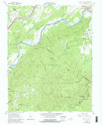
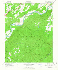
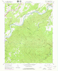
1961 Map of Arnold Valley
USGS Topo · Published 1979About this map
James River corridor developments and the deep wilderness of the Jefferson National Forest define this 1960s landscape, later updated in the late 1970s. The river is a busy transportation artery, carrying both the Chesapeake and Ohio and the Norfolk and Western railroads through the mountain gaps. Significant local history is anchored at Glenwood Furnace, a remnant of the region's early industrial efforts, while modern defense needs are represented by the Bedford Air Force Station atop the high ridges. Genealogists will find numerous family-named landmarks and resting places, such as the Robinson Cem, Bryant Cem, and Watson Cem. The terrain is marked by steep ridges like Skillern Mountain and Apple Orchard Mountain, where the Appalachian Trail and Floyd Trail provide passage through the dense forest.
Find a feature on this map
86 named features on this map. Tap any name to fly to it.
Don’t see what you’re looking for? This feature index may not catch every label — zoom into the map to look around manually.
Map Details
Editions of this 1961 Arnold Valley Map
3 editions found
Other maps of this area

1890 · Roanoke
USGS Topo · 1:125,000

1891 · Roanoke
USGS Topo · 1:125,000

1892 · Lynchburg
USGS Topo · 1:125,000

1894 · Natural Bridge
USGS Topo · 1:125,000

1894 · Lexington
USGS Topo · 1:125,000

1894 · Natural Bridge
USGS Topo · 1:62,500

1907 · Natural Bridge Special
USGS Topo · 1:62,500

1935 · Buena Vista
USGS Topo · 1:48,000

1939 · Buena Vista
USGS Topo · 1:62,500

1940 · Buena Vista
USGS Topo · 1:62,500