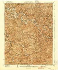
1927 Map of Arnoldsburg
USGS Topo · Published 1939About this map
The Little Kanawha River dictates the settlement pattern of this central West Virginia landscape, winding through a dense network of ridges and narrow valleys. This survey, revised in the mid-1920s, reveals a rural society built upon small crossroads and numerous neighborhood institutions. The density of education is remarkable, with one-room schoolhouses such as Klipstine School, Riverview School, and Lynch School serving isolated hollows.
Find a feature on this map
147 named features on this map. Tap any name to fly to it.
Don’t see what you’re looking for? This feature index may not catch every label — zoom into the map to look around manually.
Map Details
Editions of this 1927 Arnoldsburg Map
3 editions found

Other maps of this area

1893 · Sutton
USGS Topo · 1:125,000

1906 · Holbrook
USGS Topo · 1:62,500

1906 · Glenville
USGS Topo · 1:62,500

1906 · Elizabeth
USGS Topo · 1:62,500

1906 · Otter
USGS Topo · 1:62,500

1906 · Walton
USGS Topo · 1:62,500

1907 · Otter
USGS Topo · 1:62,500

1907 · Harrisville
USGS Topo · 1:62,500

1907 · Arnoldsburg
USGS Topo · 1:62,500

1907 · Spencer
USGS Topo · 1:62,500