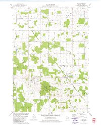
1979 Map of Arpin
USGS Topo · Published 1980About this map
Powers Bluff County Park rises as a distinct topographical landmark above the surrounding farm and timber lands of central Wisconsin. This late-1970s landscape reveals a deeply rooted rural community, where small settlements like Arpin and Bethel serve as anchors for a network of family-named roads and country institutions. The map is particularly notable for its genealogical density, preserving the locations of numerous burial grounds including Slidre Cem, Bethel Cem, and the uniquely named John Ne-Wee Cem and Indian Bill Cem. Transport and industry are marked by the crossing of the Soo Line and Chicago And North Western railroads, which facilitated the movement of goods from the area's many sandpits, gravel pits, and quarries. From the Arpin Sch to the North Arpin Ch, the map documents the infrastructure of a mid-century dairy and quarrying region at a moment of transition.
Find a feature on this map
48 named features on this map. Tap any name to fly to it.
Don’t see what you’re looking for? This feature index may not catch every label — zoom into the map to look around manually.
Map Details
Editions of this 1979 Arpin Map
This is the sole edition of this map. No revisions or reprints were ever made.
Other maps of this area

1953 · Eau Claire
USGS Topo · 1:250,000

1954 · Marshfield
USGS Topo · 1:62,500

1955 · Green Bay
USGS Topo · 1:250,000

1956 · Milladore
USGS Topo · 1:48,000

1957 · Wisconsin Rapids
USGS Topo · 1:48,000

1957 · Pittsville
USGS Topo · 1:48,000

1958 · Eau Claire
USGS Topo · 1:250,000

1964 · Eau Claire
USGS Topo · 1:250,000

1967 · Wisconsin Rapids
USGS Topo · 1:62,500

1967 · Pittsville
USGS Topo · 1:62,500