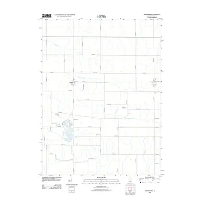
2012 Map of Arrowsmith
USGS Topo · Published 2012About this map
The Sangamon River meanders across this Central Illinois landscape, providing a natural contrast to the rigid grid of rural roads that define McLean County. Between the small agricultural centers of Ellsworth and Arrowsmith, the terrain is marked by a legacy of early settlement visible through numerous family and community burial grounds, including Frankeberger Cem, Dawson Cem, and Payne Cem. A significant recreational and geographic feature is Dawson Lake, which sits at the heart of the area, accessible via Moraine View Park Rd. The map also traces the upper reaches of Money Cr in the north, showing how these waterways influenced the placement of original homesteads and the eventual development of the township's infrastructure.
Find a feature on this map
50 named features on this map. Tap any name to fly to it.
Don’t see what you’re looking for? This feature index may not catch every label — zoom into the map to look around manually.
Map Details
Editions of this 2012 Arrowsmith Map
This is the sole edition of this map. No revisions or reprints were ever made.
Other maps of this area

1926 · Normal
USGS Topo · 1:62,500

1930 · Normal
USGS Topo · 1:62,500

1951 · Le Roy
USGS Topo · 1:62,500

1952 · Arrowsmith
USGS Topo · 1:62,500

1957 · Colfax
USGS Topo · 1:62,500

1958 · Peoria
USGS Topo · 1:250,000

1961 · Peoria
USGS Topo · 1:250,000

1963 · Peoria
USGS Topo · 1:250,000
1981 · Holder
USGS Topo · 1:24,000
1981 · Merna
USGS Topo · 1:24,000