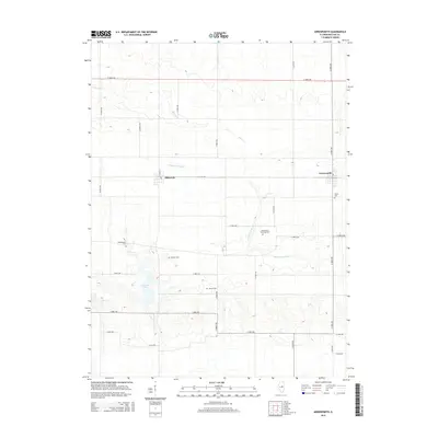
2015 Map of Arrowsmith
USGS Topo · Published 2015About this map
Ellsworth and Arrowsmith anchor this central Illinois landscape, which is defined by the headwaters of the Sangamon River and the winding course of Money Cr. This 2015 survey reveals a terrain meticulously organized by a grid of rural roads, including E 1400 N Rd and N 3000 E Rd, reflecting the region's enduring agricultural layout. A notable point of geographic interest is Dawson Lake, which provides a significant break in the surrounding topography. For those interested in local history and genealogy, the map identifies several small burial grounds scattered across the countryside, such as Frankeberger Cem, Dawson Cem, and Barnes Cem, each serving as a marker of the families who established these townships. The spatial relationship between these sites and the nearby Arrowsmith Township Cem illustrates the early settlement patterns that emerged along the river valleys and prairie rises.
Find a feature on this map
27 named features on this map. Tap any name to fly to it.
Don’t see what you’re looking for? This feature index may not catch every label — zoom into the map to look around manually.
Map Details
Editions of this 2015 Arrowsmith Map
This is the sole edition of this map. No revisions or reprints were ever made.
Other maps of this area

1926 · Normal
USGS Topo · 1:62,500

1930 · Normal
USGS Topo · 1:62,500

1951 · Le Roy
USGS Topo · 1:62,500

1952 · Arrowsmith
USGS Topo · 1:62,500

1957 · Colfax
USGS Topo · 1:62,500

1958 · Peoria
USGS Topo · 1:250,000

1961 · Peoria
USGS Topo · 1:250,000

1963 · Peoria
USGS Topo · 1:250,000
1981 · Holder
USGS Topo · 1:24,000
1981 · Merna
USGS Topo · 1:24,000