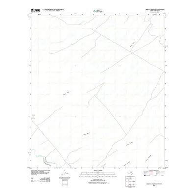
2010 Map of Arroyo Melado
USGS Topo · Published 2010About this map
The Rio Grande snakes along the international boundary between the United States and Mexico, defining the southern edge of this West Texas landscape. Near the river, FM 170 provides the primary transit corridor, passing by the small settlement of Ochoa and the adjacent Ochoa Cemetery. The terrain is characterized by a dense network of seasonal drainages that feed toward the river valley, including Wilson Arroyo, Arroyo Melado, and Arroyo Chillon. These drainage patterns reflect the arid environment where water flow is intermittent but has deeply carved the local topography. Farther north, Spencer Creek and Arroyo Rodriguez trace the paths of water through the desert scrubland, illustrating the complex hydrology of the Big Bend region before the river turns south toward the Mexican interior.
Find a feature on this map
11 named features on this map. Tap any name to fly to it.
Don’t see what you’re looking for? This feature index may not catch every label — zoom into the map to look around manually.
Map Details
Editions of this 2010 Arroyo Melado Map
This is the sole edition of this map. No revisions or reprints were ever made.
Other maps of this area

1896 · Ruidosa
USGS Topo · 1:125,000

1896 · Shafter
USGS Topo · 1:125,000

1959 · Presidio
USGS Topo · 1:250,000

1965 · Presidio
USGS Topo · 1:250,000

1966 · Adobes
USGS Topo · 1:24,000

1978 · La Boquilla
USGS Topo · 1:24,000
1979 · Indio
USGS Topo · 1:24,000
1979 · Presidio West
USGS Topo · 1:24,000

1979 · Presidio East
USGS Topo · 1:24,000

1980 · Arroyo Melado
USGS Topo · 1:24,000