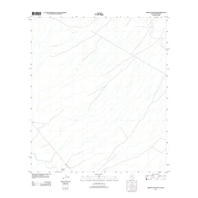
2012 Map of Arroyo Melado
USGS Topo · Published 2012About this map
Rio Grande waters define the southwestern boundary of this borderland terrain, where the river carves a winding path through the arid landscape. The settlement of Arroyo Melado sits near the river's edge, connected to the wider region by the winding path of Ranch Road 170. This map captures a specific moment in the early 21st century along the Texas-Chihuahua border, illustrating the sparse human footprint in this environment. Away from the river, the land is marked by seasonal drainage patterns like Spencer Cr and the quiet presence of the Ochoa Cem, a significant site for local family history and genealogical research in this isolated stretch of the border.
Find a feature on this map
5 named features on this map. Tap any name to fly to it.
Don’t see what you’re looking for? This feature index may not catch every label — zoom into the map to look around manually.
Map Details
Editions of this 2012 Arroyo Melado Map
This is the sole edition of this map. No revisions or reprints were ever made.
Other maps of this area

1896 · Ruidosa
USGS Topo · 1:125,000

1896 · Shafter
USGS Topo · 1:125,000

1959 · Presidio
USGS Topo · 1:250,000

1965 · Presidio
USGS Topo · 1:250,000

1966 · Adobes
USGS Topo · 1:24,000

1978 · La Boquilla
USGS Topo · 1:24,000
1979 · Indio
USGS Topo · 1:24,000
1979 · Presidio West
USGS Topo · 1:24,000

1979 · Presidio East
USGS Topo · 1:24,000

1980 · Arroyo Melado
USGS Topo · 1:24,000