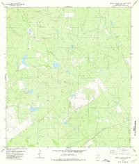
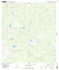
1980 Map of Arroyo Salado East
USGS Topo · Published 1980About this map
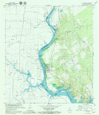
Arroyo Salado winds through this South Texas landscape in Zapata County, recorded here as it appeared in the mid-1970s. The terrain is characterized by a network of intermittent drainages and small catchment basins, typical of the brush country along the Rio Grande valley. Local infrastructure is minimal, centered largely on the energy sector as evidenced by a Gas Well in the southeastern quadrant. The map also traces Cañada Creek through the southeast, showing how water management and natural drainage patterns dictated the layout of fence lines and ranch tracks in this semi-arid environment. This survey provides a precise view of the rural industrial and hydrological layout of the region before further modern developments altered the local ranching corridors.
Find a feature on this map
3 named features on this map. Tap any name to fly to it.
Don’t see what you’re looking for? This feature index may not catch every label — zoom into the map to look around manually.
Map Details
Editions of this 1980 Arroyo Salado East Map
2 editions found
Other maps of this area

1933 · Becerra Creek
USGS Topo · 1:62,500
1940 · Aguilares
USGS Topo · 1:62,500
1940 · Mogotes Hill
USGS Topo · 1:62,500
1942 · San Ygnacio
USGS Topo · 1:62,500
1956 · Mogotes Hill
USGS Topo · 1:62,500

1956 · Laredo
USGS Topo · 1:250,000
1979 · San Ygnacio
USGS Topo · 1:24,000

1979 · O'Keefe Lake
USGS Topo · 1:24,000
1980 · Mogotes Hill
USGS Topo · 1:24,000

1980 · Agua Azul Creek West
USGS Topo · 1:24,000