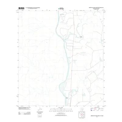
2013 Map of Arroyo Salado West
USGS Topo · Published 2013About this map
The Rio Grande defines the western edge of this South Texas borderland, where the winding river channel meets a landscape of intermittent creeks and ranch reservoirs. At the northern bend of the river sits Poblacion de Dolores, a settlement situated near the confluence where Dolores Cr and the larger Arroyo Dolores drain into the main waterway. This arid terrain is marked by engineered water management for livestock and agriculture, evidenced by features such as La Perla Ranch Lake Number 3 and La Perla Ranch Lake Number 4. Further south, the prominent Arroyo Salado carves through the brushland, illustrating the drainage patterns that have shaped land use and ranching boundaries in Zapata County for generations.
Find a feature on this map
7 named features on this map. Tap any name to fly to it.
Don’t see what you’re looking for? This feature index may not catch every label — zoom into the map to look around manually.
Map Details
Editions of this 2013 Arroyo Salado West Map
This is the sole edition of this map. No revisions or reprints were ever made.
Other maps of this area

1933 · Becerra Creek
USGS Topo · 1:62,500

1942 · San Ygnacio
USGS Topo · 1:62,500

1956 · Laredo
USGS Topo · 1:250,000
1979 · Isla Mesteno
USGS Topo · 1:24,000
1979 · San Ygnacio
USGS Topo · 1:24,000

1979 · O'Keefe Lake
USGS Topo · 1:24,000
1980 · Blancas Creek South
USGS Topo · 1:24,000
1980 · Arroyo Salado East
USGS Topo · 1:24,000
1980 · Arroyo Burro
USGS Topo · 1:24,000
1985 · San Ygnacio
USGS Topo · 1:100,000