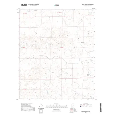
2023 Map of Arroyo Serrano East
USGS Topo · Published 2023About this map
Arroyo Serrano and its complex network of seasonal drainage channels define this Lincoln County landscape, where the high desert terrain is etched by the Middle Arroyo and Arroyo Seco. The area reflects a sparse, ranching-oriented land use pattern typical of south-central New Mexico, organized by the Public Land Survey System grids of t7s r19e and t8s r19e. Notable geographic features like Walnut Draw and the Zeufeldt Arroyo provide essential landmarks in a region dominated by relief and water-carved topography. Connectivity across this open country is maintained by a system of county routes, including Co Rd 8026 and Co Rd 8031, which follow the natural contours of the land to link remote homesteads and grazing tracts.
Find a feature on this map
16 named features on this map. Tap any name to fly to it.
Don’t see what you’re looking for? This feature index may not catch every label — zoom into the map to look around manually.
Map Details
Editions of this 2023 Arroyo Serrano East Map
This is the sole edition of this map. No revisions or reprints were ever made.
Other maps of this area

1936 · Arabela
USGS Topo · 1:48,000

1942 · Arabela
USGS Topo · 1:62,500

1955 · Roswell
USGS Topo · 1:250,000

1958 · Roswell
USGS Topo · 1:250,000

1962 · Roswell
USGS Topo · 1:250,000

1967 · North Lake
USGS Topo · 1:24,000

1967 · White Flat
USGS Topo · 1:24,000
1967 · Elsie Canyon
USGS Topo · 1:24,000
1979 · Salt Creek
USGS Topo · 1:100,000

1981 · Huff Hill
USGS Topo · 1:24,000