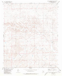
1981 Map of Arroyo Serrano East
USGS Topo · Published 1981About this map
Arid drainage patterns and isolated ranching outposts define this high-desert landscape in Lincoln County during the early 1980s. The topography is dominated by the winding paths of Arroyo Serrano, Arroyo Seco, and the smaller Arroyo Middle, which carve through the terrain toward the south and east. Human presence is sparse, centered on established homesteads like Corn Ranch and Bird Ranch, along with the localized settlement at Plainview.
Find a feature on this map
12 named features on this map. Tap any name to fly to it.
Don’t see what you’re looking for? This feature index may not catch every label — zoom into the map to look around manually.
Map Details
Editions of this 1981 Arroyo Serrano East Map
This is the sole edition of this map. No revisions or reprints were ever made.
Other maps of this area

1936 · Arabela
USGS Topo · 1:48,000

1942 · Arabela
USGS Topo · 1:62,500

1955 · Roswell
USGS Topo · 1:250,000

1958 · Roswell
USGS Topo · 1:250,000

1962 · Roswell
USGS Topo · 1:250,000

1967 · North Lake
USGS Topo · 1:24,000

1967 · White Flat
USGS Topo · 1:24,000
1967 · Elsie Canyon
USGS Topo · 1:24,000
1979 · Salt Creek
USGS Topo · 1:100,000

1981 · Huff Hill
USGS Topo · 1:24,000