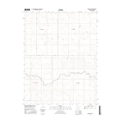
2016 Map of Arsenic Lake
USGS Topo · Published 2016About this map
Arsenic Lake and the meandering path of Rush Creek define this section of the High Plains in Cheyenne County. This survey documents the expansive cattle country of Eastern Colorado, where the landscape is organized by a sparse but vital grid of section roads including Co Rd 10, Co Rd J, and Co Rd G. The presence of ephemeral water sources like the creek bed suggests the seasonal challenges faced by ranchers in this arid environment. Land researchers and local historians can trace the precise boundaries of townships t15s r50w and t16s r49w, which underpin the historic property divisions of the region. The map reflects a modern era of land management while preserving the traditional names of local landmarks that have served as navigational touchstones for generations.
Find a feature on this map
12 named features on this map. Tap any name to fly to it.
Don’t see what you’re looking for? This feature index may not catch every label — zoom into the map to look around manually.
Map Details
Editions of this 2016 Arsenic Lake Map
This is the sole edition of this map. No revisions or reprints were ever made.
Other maps of this area

1891 · Arroyo
USGS Topo · 1:125,000

1891 · Kit Carson
USGS Topo · 1:125,000

1893 · Arroyo
USGS Topo · 1:125,000

1893 · Kit Carson
USGS Topo · 1:125,000

1954 · Lamar
USGS Topo · 1:250,000

1958 · Lamar
USGS Topo · 1:250,000

1978 · Galatea NE
USGS Topo · 1:24,000
1978 · Wild Horse
USGS Topo · 1:24,000
1978 · Galatea
USGS Topo · 1:24,000

1981 · Cheyenne Wells
USGS Topo · 1:100,000