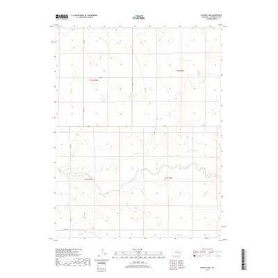
2019 Map of Arsenic Lake
USGS Topo · Published 2019About this map
Arsenic Lake sits in the high plains of Cheyenne County, marking a distinctive natural depression in an otherwise steady expanse of eastern Colorado terrain. This 2019 survey captures the drainage patterns of Rush Creek, which meanders across the southern half of the quadrangle. The landscape is defined by a rigid grid of county roads, including Co Rd J and Co Rd G, which trace the section lines established by the Public Land Survey System. These routes provide the primary infrastructure for the large-scale agricultural and ranching operations that characterize the region. The map provides a clear look at the township and range boundaries, such as t15s r50w and t16s r49w, illustrating how the land was partitioned and managed. The sparse settlement pattern and the seasonal nature of the water features reflect the semi-arid environment of the High Plains.
Find a feature on this map
13 named features on this map. Tap any name to fly to it.
Don’t see what you’re looking for? This feature index may not catch every label — zoom into the map to look around manually.
Map Details
Editions of this 2019 Arsenic Lake Map
This is the sole edition of this map. No revisions or reprints were ever made.
Other maps of this area

1891 · Arroyo
USGS Topo · 1:125,000

1891 · Kit Carson
USGS Topo · 1:125,000

1893 · Arroyo
USGS Topo · 1:125,000

1893 · Kit Carson
USGS Topo · 1:125,000

1954 · Lamar
USGS Topo · 1:250,000

1958 · Lamar
USGS Topo · 1:250,000

1978 · Galatea NE
USGS Topo · 1:24,000
1978 · Wild Horse
USGS Topo · 1:24,000
1978 · Galatea
USGS Topo · 1:24,000

1981 · Cheyenne Wells
USGS Topo · 1:100,000