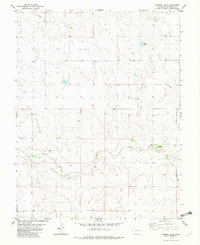
1982 Map of Arsenic Lake
USGS Topo · Published 1982About this map
Arsenic Lake and the winding course of Rush Creek define this section of the High Plains in Cheyenne County during the early 1980s. The landscape is marked by the industrial infrastructure of the era, notably the presence of multiple Pipelines and a Gravel Pit. A historical transport route is visible in the form of an Old Railroad Grade running through the eastern portion of the quadrangle. This survey, based on 1975 aerial photography, documents a transition in land use where earlier rail infrastructure was giving way to energy transport, evidenced by scattered Tank sites and gas-related labels. The terrain is largely defined by the drainage patterns of the creek and its numerous intermittent tributaries, providing a detailed look at the water resources vital to this arid region.
Find a feature on this map
8 named features on this map. Tap any name to fly to it.
Don’t see what you’re looking for? This feature index may not catch every label — zoom into the map to look around manually.
Map Details
Editions of this 1982 Arsenic Lake Map
This is the sole edition of this map. No revisions or reprints were ever made.
Other maps of this area

1891 · Arroyo
USGS Topo · 1:125,000

1891 · Kit Carson
USGS Topo · 1:125,000

1893 · Arroyo
USGS Topo · 1:125,000

1893 · Kit Carson
USGS Topo · 1:125,000

1954 · Lamar
USGS Topo · 1:250,000

1958 · Lamar
USGS Topo · 1:250,000

1978 · Galatea NE
USGS Topo · 1:24,000
1978 · Wild Horse
USGS Topo · 1:24,000
1978 · Galatea
USGS Topo · 1:24,000

1981 · Cheyenne Wells
USGS Topo · 1:100,000