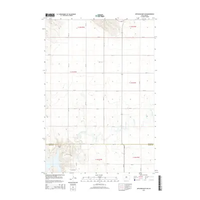
2015 Map of Artichoke Butte NE
USGS Topo · Published 2015About this map
Artichoke Creek meanders through this portion of the Dakota plains, defining the drainage patterns of a landscape marked by systematic township grids and occasional sharp coulees. The map records a rural area at the border of Potter Co and Sully Co, where the land begins to drop toward the Missouri River basin. This descent is evident in the western reaches of the survey, where Spring Draw cuts through the terrain near the Sutton Bay Entrance. The network of section line roads, including 290th Ave and 170th St, reveals a sparse settlement pattern dominated by large-scale agricultural and grazing tracts. The juxtaposition of strictly linear road alignments with the fluid path of Artichoke Cr provides a clear view of how the Public Land Survey System was imposed upon the natural hydrology of the Great Plains.
Find a feature on this map
26 named features on this map. Tap any name to fly to it.
Don’t see what you’re looking for? This feature index may not catch every label — zoom into the map to look around manually.
Map Details
Editions of this 2015 Artichoke Butte NE Map
This is the sole edition of this map. No revisions or reprints were ever made.
Other maps of this area

1953 · McIntosh
USGS Topo · 1:250,000

1954 · Pierre
USGS Topo · 1:250,000

1958 · Pierre
USGS Topo · 1:250,000

1958 · McIntosh
USGS Topo · 1:250,000

1965 · Artichoke Butte
USGS Topo · 1:24,000

1965 · Agar SW
USGS Topo · 1:24,000

1965 · Artichoke Butte SW
USGS Topo · 1:24,000

1969 · Artichoke Butte NW
USGS Topo · 1:24,000

1969 · Patch Skin Buttes SW
USGS Topo · 1:24,000

1969 · Patch Skin Buttes SE
USGS Topo · 1:24,000