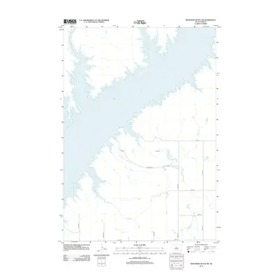
2012 Map of Artichoke Butte SW
USGS Topo · Published 2012About this map
Lake Oahe dominates the northwestern portion of this terrain in South Dakota, where the Missouri River valley was transformed by mid-century damming. The landscape above the water line is defined by a sparse network of section-line roads, including 287th Ave and 182nd St, serving isolated homesteads and prairie reaches. In this quiet landscape, Blair Cem stands as a focal point for genealogical research, situated near the headwaters of Fuller Lake. The drainage of Bloody Run meanders toward the reservoir, illustrating the local topography of small creek beds and seasonal basins. This survey provides a clear look at the intersection of local infrastructure and the massive scale of the Oahe reservoir project during the early 21st century.
Find a feature on this map
15 named features on this map. Tap any name to fly to it.
Don’t see what you’re looking for? This feature index may not catch every label — zoom into the map to look around manually.
Map Details
Editions of this 2012 Artichoke Butte SW Map
This is the sole edition of this map. No revisions or reprints were ever made.
Other maps of this area

1954 · Pierre
USGS Topo · 1:250,000

1958 · Pierre
USGS Topo · 1:250,000

1965 · Artichoke Butte
USGS Topo · 1:24,000

1965 · Okobojo NE
USGS Topo · 1:24,000

1965 · Artichoke Butte SW
USGS Topo · 1:24,000

1965 · Okobojo
USGS Topo · 1:24,000

1969 · No Heart Creek SE
USGS Topo · 1:24,000

1969 · Artichoke Butte NW
USGS Topo · 1:24,000
1970 · Artichoke Butte NE
USGS Topo · 1:24,000
1973 · Mail Shack Creek
USGS Topo · 1:24,000