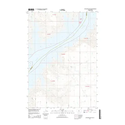
2015 Map of Artichoke Butte SW
USGS Topo · Published 2015About this map
Lake Oahe and the Missouri River dominate this Central South Dakota landscape, marking the boundary between Dewey and Sully Counties. The terrain is defined by the significant incision of watercourses into the plains, with Bull Creek and Bull Cr feeding the river from the northwest while Bloody Run carves through the southern sections. This 2015 perspective illustrates the modern rural infrastructure of the region, where a geometric grid of roads like 178th St and 288th Ave navigates the complex shoreline and draws together the scattered agricultural sections.
Find a feature on this map
27 named features on this map. Tap any name to fly to it.
Don’t see what you’re looking for? This feature index may not catch every label — zoom into the map to look around manually.
Map Details
Editions of this 2015 Artichoke Butte SW Map
This is the sole edition of this map. No revisions or reprints were ever made.
Other maps of this area

1954 · Pierre
USGS Topo · 1:250,000

1958 · Pierre
USGS Topo · 1:250,000

1965 · Artichoke Butte
USGS Topo · 1:24,000

1965 · Okobojo NE
USGS Topo · 1:24,000

1965 · Artichoke Butte SW
USGS Topo · 1:24,000

1965 · Okobojo
USGS Topo · 1:24,000

1969 · No Heart Creek SE
USGS Topo · 1:24,000

1969 · Artichoke Butte NW
USGS Topo · 1:24,000
1970 · Artichoke Butte NE
USGS Topo · 1:24,000
1973 · Mail Shack Creek
USGS Topo · 1:24,000