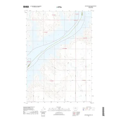
2017 Map of Artichoke Butte SW
USGS Topo · Published 2017About this map
Lake Oahe and the Missouri River dominate this Central South Dakota landscape, defining the jagged boundary between Dewey and Sully Counties. The terrain is deeply incised by drainages such as Bull Creek and Bloody Run, illustrating the erosional patterns common to the Missouri Plateau. Away from the main reservoir, Fuller Lake provides a smaller water feature within the upland draws. Human presence is sparse, marked primarily by the section-line grid of rural routes like 182nd St and 286th Ave. For those researching local history or genealogy, the Blair Cem sits as a solitary landmark on the prairie, while the presence of named draws and runs reflects the essential role of water management and topography in this ranching region during the early 21st century.
Find a feature on this map
27 named features on this map. Tap any name to fly to it.
Don’t see what you’re looking for? This feature index may not catch every label — zoom into the map to look around manually.
Map Details
Editions of this 2017 Artichoke Butte SW Map
This is the sole edition of this map. No revisions or reprints were ever made.
Other maps of this area

1954 · Pierre
USGS Topo · 1:250,000

1958 · Pierre
USGS Topo · 1:250,000

1965 · Artichoke Butte
USGS Topo · 1:24,000

1965 · Okobojo NE
USGS Topo · 1:24,000

1965 · Artichoke Butte SW
USGS Topo · 1:24,000

1965 · Okobojo
USGS Topo · 1:24,000

1969 · No Heart Creek SE
USGS Topo · 1:24,000

1969 · Artichoke Butte NW
USGS Topo · 1:24,000
1970 · Artichoke Butte NE
USGS Topo · 1:24,000
1973 · Mail Shack Creek
USGS Topo · 1:24,000