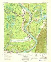
1967 Map of Artonish
USGS Topo · Published 1968About this map
Fort Adams stands on the eastern bluffs overlooking a complex hydrologic landscape where the Mississippi River, Old River, and Red River systems converge. This mid-1960s perspective captures the massive engineering of the Old River Control Structure and its Outflow Channel, designed to manage the distribution of water between the Mississippi and the Atchafalaya basins. The map illustrates a region dominated by the shifting hydrology of the river, with extensive wetlands such as the Dismal Swamp and Devils Swamp surrounding numerous oxbow lakes like Lake Mary and Grassy Lake.
Find a feature on this map
95 named features on this map. Tap any name to fly to it.
Don’t see what you’re looking for? This feature index may not catch every label — zoom into the map to look around manually.
Map Details
Editions of this 1967 Artonish Map
This is the sole edition of this map. No revisions or reprints were ever made.
Other maps of this area

1906 · Bayou Sara
USGS Topo · 1:125,000

1935 · Tooleys
USGS Topo · 1:62,500

1936 · Woodville
USGS Topo · 1:62,500

1939 · St. Francisville
USGS Topo · 1:62,500

1939 · Kingston
USGS Topo · 1:62,500

1939 · Artonish
USGS Topo · 1:62,500

1939 · Deer Park
USGS Topo · 1:62,500

1941 · Voorhies
USGS Topo · 1:62,500

1941 · Batchelor
USGS Topo · 1:62,500

1941 · Tooleys
USGS Topo · 1:62,500