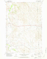
1971 Map of Arvada NE
USGS Topo · Published 1975About this map
The Powder River cuts through the arid landscape of the Wyoming plains, where the Sheridan and Campbell County line marks a border through ranching country. This early 1970s survey illustrates a terrain defined by complex water drainage systems, including Wild Horse Creek and the North Prong. The presence of the Burlington Northern railroad running parallel to the river reflects the enduring importance of this transportation corridor through the Powder River Basin. For researchers and genealogists, the Arvada Cemetery is a significant local landmark, situated near the western edge of the map. The map detail is peppered with numerous flowing wells, such as those along Williams Draw, highlighting the critical role of groundwater in this high-desert environment. Rising above the drainage basins, Tincom Butte serves as a prominent navigational marker in the southern portion of the quadrangle.
Find a feature on this map
18 named features on this map. Tap any name to fly to it.
Don’t see what you’re looking for? This feature index may not catch every label — zoom into the map to look around manually.
Map Details
Editions of this 1971 Arvada NE Map
This is the sole edition of this map. No revisions or reprints were ever made.
Other maps of this area

1954 · Gillette
USGS Topo · 1:250,000

1955 · Sheridan
USGS Topo · 1:250,000

1955 · Gillette
USGS Topo · 1:250,000

1958 · Gillette
USGS Topo · 1:250,000

1958 · Sheridan
USGS Topo · 1:250,000

1962 · Gillette
USGS Topo · 1:250,000

1962 · Sheridan
USGS Topo · 1:250,000

1971 · Larey Draw
USGS Topo · 1:24,000

1971 · Cabin Creek SE
USGS Topo · 1:24,000
1971 · Kline Draw
USGS Topo · 1:24,000