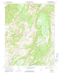
1972 Map of Asbury
USGS Topo · Published 1991About this map
Blaker Mills and Piercys Mill anchor the rural landscape of western Greenbrier County in this early 1970s survey. The map details a transition between high ridges and valley floors, where the waters of Muddy Creek and Mill Creek defined the placement of early settlements and milling operations. High points like Brushy Ridge and Muddy Mountain divide the districts of Blue Sulphur and Fort Spring, with many small country churches such as Woods Memorial Ch and Janes Chapel serving as community hubs. The presence of the Hern Mill Bridge and several family-named burial sites, including the Harrah Cem near Asbury, provides valuable documentation for genealogists and local historians tracking the agricultural and social development of the region before modern land-use changes.
Find a feature on this map
35 named features on this map. Tap any name to fly to it.
Don’t see what you’re looking for? This feature index may not catch every label — zoom into the map to look around manually.
Map Details
Editions of this 1972 Asbury Map
2 editions found
Other maps of this area

1887 · Hinton
USGS Topo · 1:125,000

1887 · Lewisburg
USGS Topo · 1:125,000

1891 · Lewisburg
USGS Topo · 1:125,000

1892 · Hinton
USGS Topo · 1:125,000

1921 · Alderson
USGS Topo · 1:48,000

1921 · White Sulphur Springs
USGS Topo · 1:48,000

1921 · Clintonville
USGS Topo · 1:48,000

1921 · Ronceverte
USGS Topo · 1:48,000

1923 · Clintonville
USGS Topo · 1:62,500

1923 · White Sulphur Springs
USGS Topo · 1:62,500