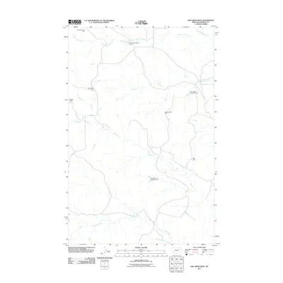
2011 Map of Ash Creek West
USGS Topo · Published 2011About this map
Coal Bank Hill and Square Butte rise above a landscape defined by an intricate network of ephemeral drainages and ranching water management in Garfield County. The terrain is dominated by the winding paths of Ash Creek, Lone Tree Creek, and the headwaters of the South Fork Box Creek. Human activity is primarily represented by a series of stock dams and reservoirs, which reflect the necessity of water storage in this arid environment. Significant features include the Harold Number 1 Dam, Pink Sketter Number 1 Dam, and the Spring- Miller Dam. The presence of Dirty Wash Reservoir Dam and the simple track of Haxby Rd highlight the sparse infrastructure of this region in the early 21st century, where the primary land use remains centered on grazing and water conservation.
Find a feature on this map
15 named features on this map. Tap any name to fly to it.
Don’t see what you’re looking for? This feature index may not catch every label — zoom into the map to look around manually.
Map Details
Editions of this 2011 Ash Creek West Map
This is the sole edition of this map. No revisions or reprints were ever made.
Other maps of this area

1954 · Jordan
USGS Topo · 1:250,000

1956 · Jordan
USGS Topo · 1:250,000

1958 · Jordan
USGS Topo · 1:250,000

1958 · Sage Creek Point
USGS Topo · 1:24,000

1964 · Jordan
USGS Topo · 1:250,000

1972 · Short Creek
USGS Topo · 1:24,000
1972 · Gilbert Creek SE
USGS Topo · 1:24,000

1972 · Flat Creek School
USGS Topo · 1:24,000
1972 · Spring Creek Bay
USGS Topo · 1:24,000
1972 · Gilbert Creek
USGS Topo · 1:24,000