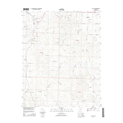
2014 Map of Ash Flat
USGS Topo · Published 2014About this map
Ash Flat and Highland anchor the northern reaches of this Sharp County landscape, where the Ozark foothills meet a complex network of spring-fed drainage. The topography is defined by the branching systems of N Big Cr and North Big Creek, which carve out significant relief such as Vaughn Hollow and King Hollow. For genealogists, the map is particularly rich in burial sites, documenting local family and community history at Old Baptist Cem, Willes Cem, Shiloh Cem, and the Center Cem in the small community of Center. The southern portion of the quadrangle transitions into a more secluded terrain of ridges and valleys, marked by the Center Lookout Tower and a labyrinth of smaller tributaries like Lick Br and Birchfield Br. This 2014 survey records a landscape where modern development along Us-412 exists alongside long-established rural settlements and traditional upland homestead patterns.
Find a feature on this map
116 named features on this map. Tap any name to fly to it.
Don’t see what you’re looking for? This feature index may not catch every label — zoom into the map to look around manually.
Map Details
Editions of this 2014 Ash Flat Map
This is the sole edition of this map. No revisions or reprints were ever made.
Other maps of this area

1957 · Poplar Bluff
USGS Topo · 1:250,000

1959 · Poplar Bluff
USGS Topo · 1:250,000

1960 · Poplar Bluff
USGS Topo · 1:250,000
1961 · Evening Shade
USGS Topo · 1:24,000

1962 · Stuart
USGS Topo · 1:24,000

1962 · Ash Flat
USGS Topo · 1:24,000
1962 · Sidney
USGS Topo · 1:24,000

1962 · Myron
USGS Topo · 1:24,000

1962 · Agnos
USGS Topo · 1:24,000
1965 · Poughkeepsie
USGS Topo · 1:24,000