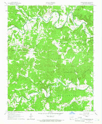
1965 Map of Poughkeepsie
USGS Topo · Published 1966About this map
The Strawberry River meanders through the heart of this mid-1960s Sharp County landscape, defining the rural character of the terrain between North Big Rock and South Big Rock. Small agricultural and residential hubs like Poughkeepsie and Nelsonville anchor the local community, while the settlement of Calamine sits further east along the South Branch Big Creek. The map reveals a dense network of country roads connecting established community centers like Lebanon Ch and Kings Chapel.
Find a feature on this map
43 named features on this map. Tap any name to fly to it.
Don’t see what you’re looking for? This feature index may not catch every label — zoom into the map to look around manually.
Map Details
Editions of this 1965 Poughkeepsie Map
2 editions found
Other maps of this area

1890 · Batesville
USGS Topo · 1:125,000

1891 · Batesville
USGS Topo · 1:125,000

1932 · Strawberry
USGS Topo · 1:62,500

1935 · Strawberry
USGS Topo · 1:62,500

1941 · Strawberry
USGS Topo · 1:62,500

1943 · Cave City
USGS Topo · 1:31,680

1953 · Memphis
USGS Topo · 1:250,000

1955 · Strawberry
USGS Topo · 1:24,000

1956 · Memphis
USGS Topo · 1:250,000

1957 · Poplar Bluff
USGS Topo · 1:250,000