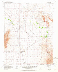
1952 Map of Ash Meadows
USGS Topo · Published 1963About this map
The Amargosa Desert and the unique wetlands of Ash Meadows define this landscape along the Nevada California border. In the early 1950s, the region was characterized by isolated ranching and mining operations, anchored by the hub at Death Valley Junction (Death Valley P O). The map traces the corridor of the Tonopah and Tidewater Railroad (Dismantled), reflecting a shift away from the heavy rail-based mineral transport that once dominated the valley. Scattered across the alkali flats and desert floor are numerous water sources and settlements, including Ash Meadows Rancho, Hog Ranch, and Franklin Well. To the east, the Resting Spring Range rises sharply, while the southern reaches of Death Valley Nat Monument and the historic Von Schmidt Line mark the transition between desert basins. Numerous Clay Pits and a Gravel Pit indicate the mid-century industrial activity sustaining these remote outposts.
Find a feature on this map
52 named features on this map. Tap any name to fly to it.
Don’t see what you’re looking for? This feature index may not catch every label — zoom into the map to look around manually.
Map Details
Editions of this 1952 Ash Meadows Map
4 editions found
Other maps of this area

1908 · Furnace Creek
USGS Topo · 1:250,000

1910 · Furnace Creek
USGS Topo · 1:250,000

1940 · Eagle Tank
USGS Topo · 1:62,500

1942 · Skull Mountain
USGS Topo · 1:125,000

1942 · Bullfrog
USGS Topo · 1:125,000

1948 · Death Valley
USGS Topo · 1:250,000

1951 · Funeral Peak
USGS Topo · 1:62,500

1951 · Eagle Mtn
USGS Topo · 1:62,500

1952 · Ash Meadows
USGS Topo · 1:62,500

1952 · Ryan
USGS Topo · 1:62,500