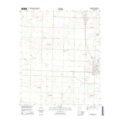
2014 Map of Ashdown West
USGS Topo · Published 2014About this map
The town of Ashdown serves as a primary hub in this southwest Arkansas landscape, situated where the terrain transitions toward the Little River floodplain. This 2014 survey captures a network of rural communities, including Wilton to the north and the settlement of Richmond to the south. The area is defined by a dense system of seasonal drainages such as Lick Cr, Beaver Cr, and Hemphill Cr, which influence the local road patterns and land use. Genealogists will find significant value in the distribution of family and community burial grounds across the quadrangle, including the Wilton Cem, Oak Hill Cem, and Rhodes Cem. The presence of the Haney Creek Watershed Site Two Reservoir in the southeast corner highlights mid-century water management efforts designed to control the runoff that feeds into Haney Cr and Hurricane Cr.
Find a feature on this map
103 named features on this map. Tap any name to fly to it.
Don’t see what you’re looking for? This feature index may not catch every label — zoom into the map to look around manually.
Map Details
Editions of this 2014 Ashdown West Map
This is the sole edition of this map. No revisions or reprints were ever made.
Other maps of this area

1950 · Redbank
USGS Topo · 1:24,000

1950 · Ashdown East
USGS Topo · 1:24,000

1950 · Ashdown West
USGS Topo · 1:24,000

1950 · Ogden
USGS Topo · 1:24,000

1950 · Ben Lomond
USGS Topo · 1:24,000

1950 · Barkman
USGS Topo · 1:24,000

1950 · Falls Chapel
USGS Topo · 1:24,000

1950 · Winthrop
USGS Topo · 1:24,000

1951 · Winthrop
USGS Topo · 1:24,000

1951 · Redbank
USGS Topo · 1:24,000